17th to the 23rd of January, 2013:
Initially I had booked 3 nights
at Gilligan’s Backpackers which I had been to the previous year, and planned to
move to smaller backpackers afterwards. However, after meeting some great
fellow travellers I extended my stay there by 4 nights. It was great to finally
have some people to party with, and Gilligan’s doesn’t disappoint, with two for
one schooners for $4, wet tee-shirt comps and on the final night there some
jelly wrestling, there is always something to keep you entertained! By far the
most common nationality of backpacker is German, which they aren’t overly
thrilled by, but I love it! They are great people so I’ll definitely have to
head over there in the next couple of years! I probably should have allocated a
day or two to ride around the surrounding national parks like Daintree, but it
was just great to give my arse a rest and to just walk around the city… maybe
next time I’m up there.
The weather during the first few
days was great, however I knew the monsoonal trough was heading south. I hoped
to sit tight and wait out the initial wave of monsoonal rain but unfortunately
the development of tropical cyclone Oswald, extended the rain. I ended up
leaving Cairns on the 23rd of January, with rain pissing down thanks
to the now ‘Ex-Tropical cyclone Oswald’. With some discouraging advice and
looks from a few locals, I loaded up the bike, chucked on the sauna gear (aka
wet weather clothing) and headed off south west for a bit via the Undara
Volcanic national park and then west to Georgetown. The rain was horrid, and at
90km/h your face feels as though it’s being exfoliated with a wire brush… I
probably should have invested in a helmet with the visor, or at least have
brought my balaclava with me! Furthermore, two piece wet weather gear is no
real match for the wet!
Just before I turned off the
Kennedy Highway onto the Gulf developmental road I came across a fellow rider
who had unfortunately got a flat on his BMW rs1200. I offered to help fix it as
I had picked up some ‘blue goo’ back in Yeppoon, but he didn’t want to use it
in case I was left stranded. Instead, he organised some assistance so I set off
again. For the most part from here the scenery and road was boring, and the
intended visit to the lava tubes in Undara was buggered up since it is only by
guided tour. The landscape changed once I got close to Georgetown where the
view from up higher is quite spectacular (in contrast to the earlier riding
anyways). Once in Georgetown I refuelled and got some accommodation in a
‘donga’ where I could hang my wet gear up and prepare for tomorrows wet ride!

The rock faces quickly became waterfalls as the rain fell in and around Cairns

Somewhere along the way to Georgetown... I've got a useless memory

The poor bugger who got a flat in the bucketing rain

Not too far from Georgetown here, where the rain let up a bit!
24th of January, 2013:
Today’s route was dictated by the
relentless rain over the night. The plan was to try and get to Karumba, a small
fishing town at the base of the Gulf of Carpentaria. If the road is clear or
passable this is my first choice. Alternatively, I would travel south west and
attempt to make it to Mt Isa, which is clear of the rain associated with the
low pressure trough. Before I headed off I checked with the police at
Georgetown who told me that the road to Normanton was clear, and hopefully the
one that extends to Karumba would be too. Again, because of the rain the route
is unfortunately way all main roads, which bores the crap outa me! Because of
this, there is nothing really exciting to tell, apart from the abundance of
road kill, which in many cases turns green and puts out a repugnant odour, where
the large eagles that strip the carcases are the only interesting occurrence.
Once I arrived in Normanton, I
refuelled and was given the all clear by the visitor information centre to
continue onto Karumba. Though it wasn’t hot, the sea breeze that came overland
was warm and salty which was somewhat uncomfortable. Once the tent was set up I
decided to sit and take in the famous sunset that graces the coastline
everyday… it didn’t disappoint. I’ve attempted a timelapse of it, which will
eventually be included in one of the trip videos, but for now you will have to
settle for the pictures below.

An old historic site.. a chimney outside of Georgetown

The curious wallaby on the floodplains behind the caravan park in Karumba.

A few more...

The sunset early on
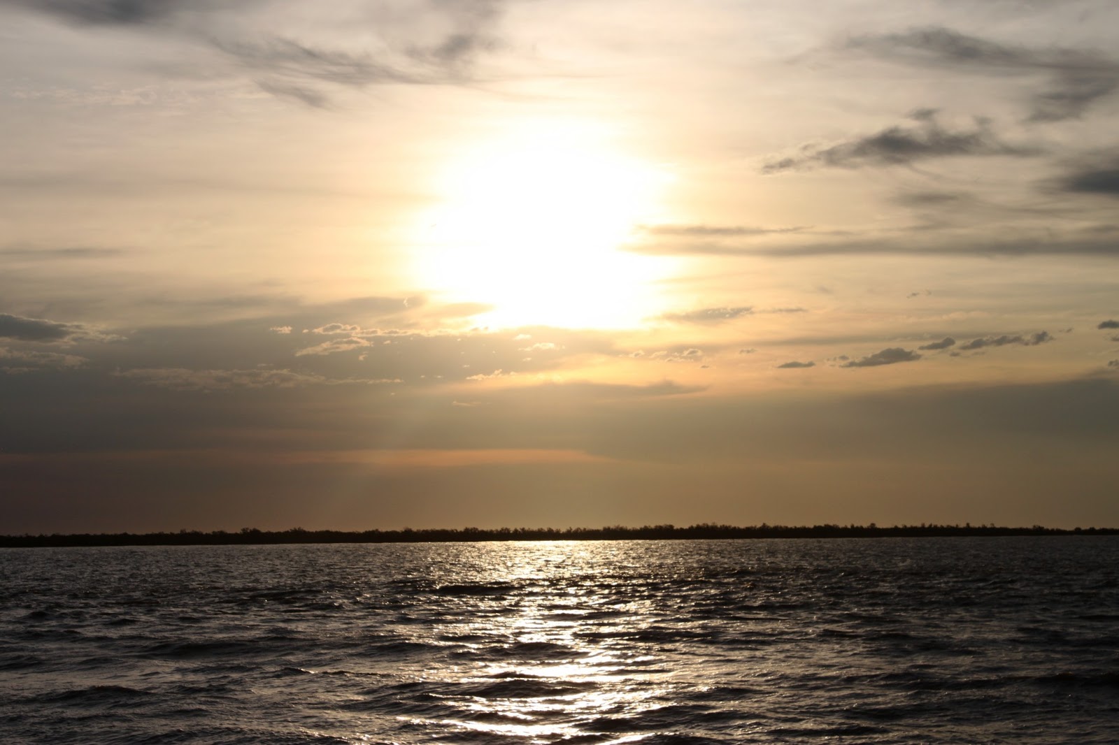


The final stages of the Sunset... spectacular!
25th of January, 2013:
The original plan today (which at
the time seems pointless) was to head west and attempt to reach Lawn Hill
National Park. Again, thanks to the good O’l wet season the unsealed roads to
Burketown were closed, which forced me South West along the sealed section of
the Burke developmental road, to Burke & Wills Roadhouse. A refill and a
chat to the locals revealed that I could make it to Gregory Downs (around 50
km’s east of Lawn Hill NP), but from there on the roads were boggy and whilst
not officially closed, the risk of getting stuck was quite high. So the highway
it was… again! To get to somewhere remotely interesting I pushed on through
Cloncurry and Mt Isa which led me too Camooweal Caves National Park at around
8pm. The ride itself was painfully hot and boring, with the only real change in
the landscape on around of Mt Isa. The rest stops that contained water tanks
gave me the chance to cool off slightly by drenching my shirt in some water,
which if I was lucky would stay wet for 10 km’s before drying again! Camooweal
Caves themselves are an underground system, with the only access point via a
series of sinkholes. Because of this the only ‘safe’ way to enter them is with
the use of abseiling and climbing equipment.
The next morning I was awoken to
the irritating sound of flies, which were persistant little fuckers! Whilst I
was desperately clutching to my sanity, the flies made me look like Peter
Garret dancing with turrets syndrome while I tried to pack the bike. Despite the flies insistence I
quickly checked out the main cave entrance before I buggered off on another
long and boring ride.
26th of January, 2013:
The goal today was the famous and
historic, Daly Waters Pub. The quickest and shortest route was 822km’s via
Barkly and Stuart Highway. Alternatively, I could have taken the Tablelands
onto the Carpentaria highway which would have added another 100km’s on top, and
would have been maybe a little more interesting.
Not much to say (or maybe I can’t
remember) but I eventually made it to the pub for Australia day, and enjoyed
the iconic surroundings of the pub, the beer, and the people. Now I’ve only
travelled and experienced a few pubs on the trip so far, but this place is by
far the coolest place I’ve visited … the pictures just don’t capture the
atmosphere, so you’ll have to go there yourself! The first few beers didn’t
even touch the sides, and were at the time, an excellent substitute for the
water that I should have been drinking! After a pub feed and the exploitation
of their self-serve salad and vegie bar to add to my beef schnitzel meal It
didn’t take long, before I was stumbling to my tent and crashed for the night.


It wasn’t the most refreshing
sleep last night, with some late night and early showers needed to cool off,
though the ‘cold’ water was what us southerners would considered warm… this
seems to be a more frequent occurrence the further north I travel. Despite the
crappy sleep, I packed up and headed to Katherine to check out the gorge within
Nitmuluk National Park. Upon arrival I was buggered and the heat was taking its
toll. So taking this into consideration I decided to skip Nitmuluk and Kakadu
on the way up and head straight for Darwin. Thankfully I had organised some
accommodation with my brother, Mark and his Girlfriend, Sanne, who have taken a
short hiatus from their own round-the-world trip on bikes. After checking out a
few of the World War II sites along the Stuart Highway and riding some of the
old airforce air strips, I made it! Thankfully the rain held off just long
enough for me to get unpacked and sorted before bucketing down, and with it a
sharp and refreshing drop in temperature and humidity!
28th of January to the 2nd of February, 2013:
The time off the bike was a
godsend, and an excellent opportunity to catch up with Mark and Sanne, sink
some beers, and attempt to acclimatise to the hot and humid conditions. Whilst
up here, we spent a day at Litchfield National Park, where the rockpools and
waterfalls provided an excellent escape from the heat. Using the time available
I thought It best to finally change the oil and filter in the bike, and come up
with a more permanent solution to the clamped off auxiliary fuel line on the
bike (which busted a few thousand kilometres ago on Fraser Island). Apart from
checking out the museum and a few of the sites around Darwin, that the stay was
pretty quiet and relaxed which was perfect to recover from the long distances
that I had been covering earlier!
Unfortunately, the week went fast
and I had to remount the bike, and Mark had to head back to the mines.
Fortunately though, both Mark and Sanne had both covered the stretch from Perth
to Darwin at the beginning of their own adventure and were able to direct me on
the sites that are worth a look!


Florence falls

Mark enjoying some of the drop offs... plenty of cool gopro footage, so you will have to wait for the rest of that!
No comments:
Post a Comment